Digitizing Airspace Management for the U.S. Air Force
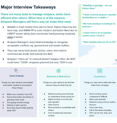
This is the first time it's felt like someone's actually listening to us. I can't believe we finally have something that makes our job easier.
The impact
Airspace creation: 40 minutes to 3 minutes. 85% of requests arrived incomplete before structured validation. MVP fed downstream mission planning apps used in active theater operations.
Spacer shipped as a working prototype within the Kessel Run software factory, integrated into the KR Event Stream feeding real-time airspace updates to Triton (ATO production) and Slapshot (Master Air Attack Planning). Slapshot's subsequent deployment to the 609th AOC in Doha validated the data pipeline operationally in a combat environment.
How we got there
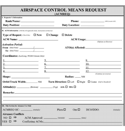
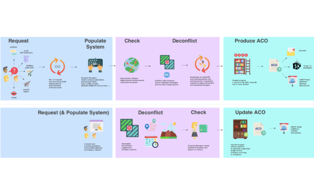
Planes should not collide mid-air. But the systems responsible for preventing that were built on paper forms, chat messages, and decades-old tools. Airspace requestors at Air Operations Centers submitted requests on cocktail napkins, via mIRC chat, or as Word docs emailed between desks. 85% arrived without necessary detail. Airspace managers deconflicted overlaps using tribal knowledge and personal memory, hand-jamming data between TBMCS, WebAD, ASMA-FP, and Falcon View. Legacy airspaces were rarely deleted, cluttering the system with ghost reservations that triggered false conflict alerts.
I embedded at Pivotal Labs with Kessel Run engineers and ran 20+ user interviews across four Air Operations Centers (607th, 609th, 612th, 613th) to understand how mission planning actually worked. I mapped the full Air Tasking & Re-Tasking cycle across 7 phases, from initial need through daily planning and execution to real-time change orders. That mapping exposed something important: the biggest win was not the deconfliction logic. It was structuring the request itself.
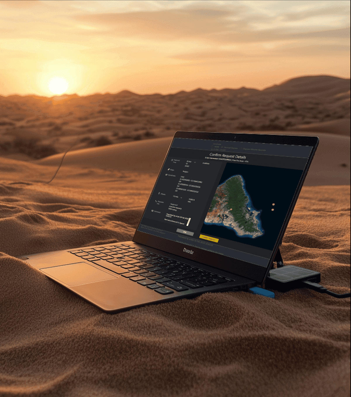
So we built a digital ACMREQ form that guided requestors to include required details from the start. Location as lat/long coordinates, altitude ranges, timing blocks, geometric shapes. The form did what napkins could not: validate inputs before they reached an airspace manager. We added automated conflict detection that suggested small shifts in time, location, or altitude, letting users resolve simple issues before they reached a human.
Officers expected a flashy, map-heavy interface. We delivered thoughtful validation and functionality first. The MVP looked nothing like the intended future product. Spacer started as what one teammate called "a glorified form." But that was exactly what users needed first. Trust came from reliability, not visual polish.
We built the system to produce ACO-ready entries in USMTF format, ensuring compatibility with existing ATR systems. Spacer published to the KR Event Stream, feeding real-time airspace data to Triton and Slapshot and replacing manual data handoffs across squadrons.
What this built
- A digital foundation for airspace coordination. Validated requests, automated conflict detection, and USMTF export replaced a fragmented system of napkins, chat, and hand-jammed legacy tools.
- A proven data pipeline for mission planning. Spacer's integration into the KR Event Stream was validated operationally when Slapshot deployed to the 609th AOC in Doha, consuming upstream airspace data in a combat environment.
- A model for shipping in high-stakes government environments. Full Pivotal methodology (XP, TDD, pair programming, balanced teams) applied to classified military software, with coaching that enabled the AF PM to transition into engineering on a sister product.


Resources & artifacts
PDFAirspace Management Product Review
Kate's full product review deck from Kessel Run: domain education, discovery findings, hypothesis, MVP demo, warfighter adoption plan, and takeaways.
Kessel Run -- Air Force Software Factory
Official Kessel Run product lines page, including the Operational Command & Control pillar where Spacer lived.
Want to bring this kind of thinking to your team?
I help teams ship products with clarity, speed, and care.